Key Takeaways
- Researchers have developed an advanced high-resolution imaging technology that can map the elemental composition of a planet or asteroid’s surface in 3D with centimeter-scale detail.
- The instrument, called INSPECT3R, can also precisely locate and accurately identify objects buried underground.
- INSPECT3R could deepen our understanding of the geochemical makeup of planets and asteroids, detect buried anomalies, support the development of a permanent lunar base, help in the search for signs of extraterrestrial life, and improve land management on Earth.
An advanced imaging technology capable of producing accurate, detailed 3D geochemical maps of a planet’s subsurface could transform how we explore other worlds, asteroids, and our own planet.
This new instrument, known as the In-Situ Nuclear Spectrometer with 3D Resolution (INSPECT3R), could deepen our understanding of the geochemical wealth of the Moon, Mars, and other planets and asteroids, as well as search for signs of life. It could also enhance our understanding of terrestrial soil geochemistry, helping to improve land management here on Earth.
The research, published in the journal npj Space Exploration, results from a collaboration between the Accelerator Technology & Applied Physics (ATAP) Division at the U.S. Department of Energy’s Lawrence Berkeley National Laboratory (Berkeley Lab), NASA Goddard Space Flight Center, and Johns Hopkins University Applied Physics Laboratory.
The idea for INSPECT3R “began when I was a postdoctoral fellow at NASA working on a similar technology for the Dragonfly mission,” says Mauricio Ayllon Unzueta, a research scientist in ATAP’s Fusion Science & Ion Beam Technology Program who led the development of INSPECT3R. (Scheduled to launch in 2028, NASA’s Dragonfly mission will explore Titan, Saturn’s largest moon, and search for evidence of life.)
“By detecting characteristic signatures of elements on the surface or buried beneath, INSPECT3R can locate and identify important materials—such as metal-rich meteorites, mineral layers, or potential water-bearing deposits—without the need for drilling or digging. It could also help search for signs of past life on places like Mars.”
The instrument could enable planetary prospecting for materials for In-Situ Resource Utilization (ISRU), a high-priority goal of the NASA ARTEMIS program, which aims to use the Moon’s resources to provide the raw materials for establishing a permanent lunar base within the next decade.
“This exciting new technology demonstrates how ATAP researchers, in partnership with other leading institutions, are helping drive new methods that advance understanding for future space exploration missions as well as terrestrial exploration and related nuclear nonproliferation,” says ATAP Division Director Cameron Geddes.
A technological leap
While planetary surface imaging technologies, such as gamma-ray and neutron spectrometers (GRNS), have been effectively deployed on the Moon, Mars, Mercury, Venus, and several asteroids, they have inherent limitations that impact their performance and restrict their applications.
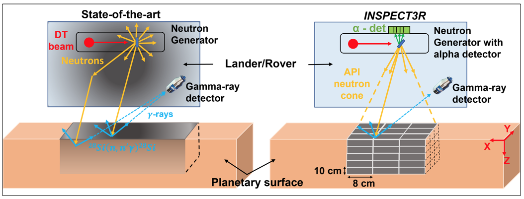
For example, ground-based GRNS suffer from low spatial resolution and limited reach, which restrict measurements to average elemental compositions over meter-scale areas, with most of the signal confined to depths of only 10 cm. Additionally, interference from background signals from the rover or lander—which can account for a large fraction of the measured signal—and natural radiation, such as cosmic rays, reduces their sensitivity and accuracy. They also require an external neutron detector to calibrate the neutron flux from GRNS with neutron generators, which can further diminish their accuracy.
To overcome these limitations, INSPECT3R employs “an active spectrometer based on a technique called Associated Particle Imaging, or API, which uses neutrons and gamma rays to produce three-dimensional images with higher spatial resolution at depths beyond those attainable by GRNS,” says Ayllon Unzueta.
An advanced neutron imaging technique, API uses deuterium–tritium (isotopes of hydrogen) fusion reactions to produce high-energy neutrons and alpha particles. When directed into the ground, these neutrons collide with atomic nuclei, generating characteristic gamma rays. API technology development was accelerated after 9/11 for homeland security applications, for example, imaging warheads and inspecting cargo. Recent developments in fast electronics and digital data acquisition systems have made the system practical (or field-deployable). Therefore, API could be a significant tool for the National Nuclear Security Administration in the future.
“Since the neutron and alpha particle travel in opposite directions, detecting the alpha particle allows for the precise determination of the neutron’s direction and timing,” explains Ayllon Unzueta.
These alpha particles act like tiny stopwatches and GPS trackers, informing INSPECT3R of the timing and direction of a generated neutron. Since each element emits gamma rays with distinct energies, measuring these energies allows for the identification of the elements present. Additionally, because each alpha particle is linked to a gamma ray, they can be used to “tag” the location where the neutron interacts with a nucleus, allowing for a three-dimensional reconstruction of the subsurface elemental composition.
This directional tagging greatly reduces background noise because the instrument detects gamma rays from the planetary surface only if they arrive within a short time window after an alpha particle is detected. And because the background noise “is not correlated in time with the alpha particle tag,” explains Ayllon Unzueta, “the instrument filters out this noise, enhancing accuracy.”
By enabling non-destructive soil imaging, INSPECT3R “transforms the landscape of sample collection and resource exploration,” says Arun Persaud, who leads ATAP’s Fusion Science & Ion Beam Technology Program.
“This capability is especially crucial in remote locations where access is limited, allowing us to gather vital geochemical information without the need for extensive sampling. It paves the way for more efficient and effective exploration of our solar system and beyond, maximizing the scientific knowledge we can gain from every planetary mission.”
Delving deeper with greater precision
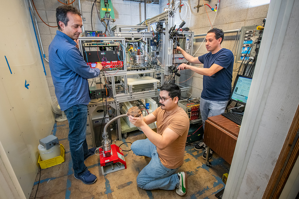
To evaluate the INPSECTR3’s ability to map the geochemical composition of a lunar surface, the researchers irradiated various lunar regolith simulants—terrestrial material that has been synthesized to approximate lunar soil. These samples were arranged next to each other to test the instrument’s horizontal resolution and stacked in layers to examine its depth resolution.
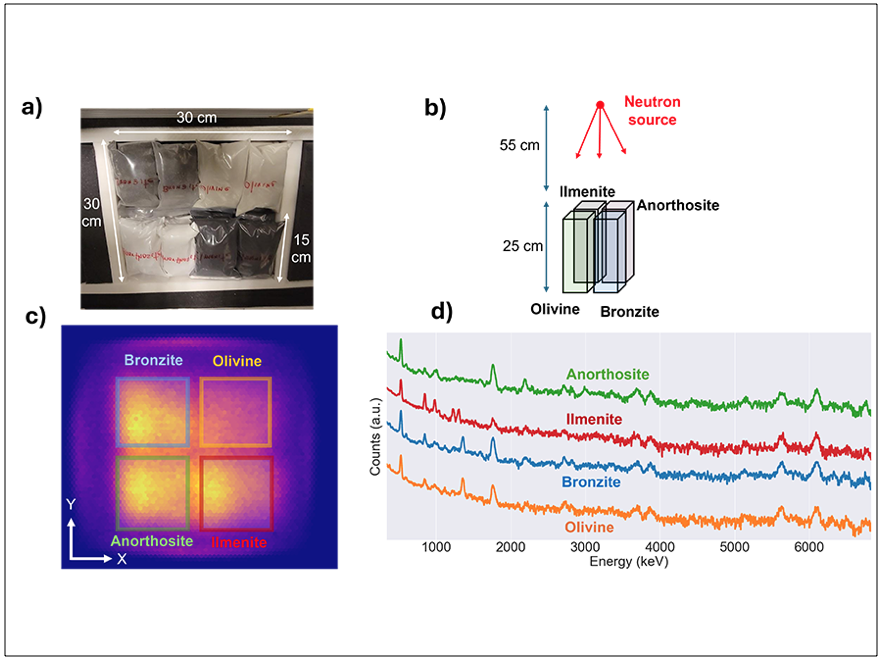
The system successfully identified and mapped these minerals by detecting gamma-ray signatures associated with elements such as titanium, aluminum, iron, magnesium, and oxygen. It also accurately separated all the regolith components within a horizontal resolution of about 9 cm and precisely determined the elemental composition to a depth of 45 cm, with an estimated depth resolution of 10 cm.
“These spatial resolutions were not only much better than we expected,” says Ayllon Unzueta, “but we were also very excited to see that there was very little interference from signals from samples placed next to each other.
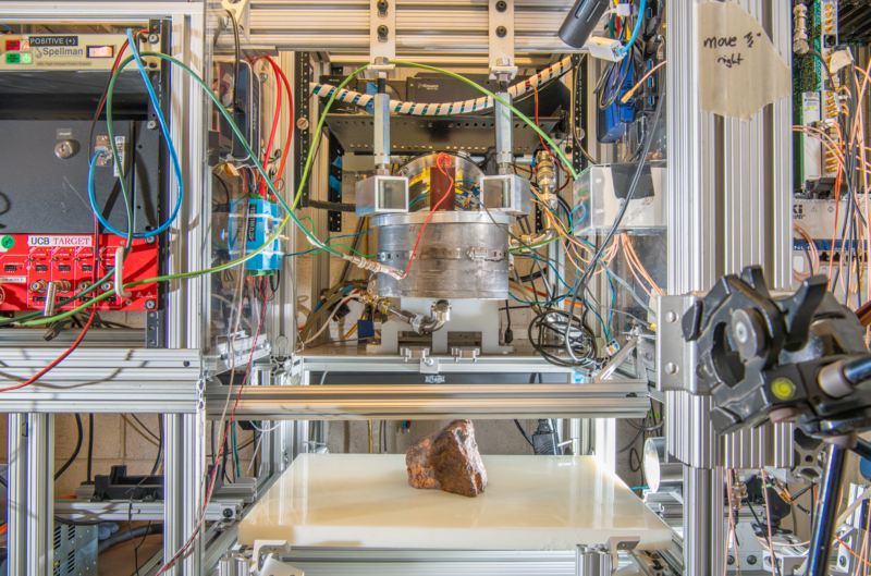
By placing an iron-nickel “Toluca” meteorite at different depths within a large aluminum box filled with soil, the team assessed its ability to locate and identify an object based on its elemental composition. After irradiation, the resulting 3D compositional maps showed the meteorite’s distinctive gamma-ray signatures with a resolution of 10 cm up to a depth of approximately 30 cm.
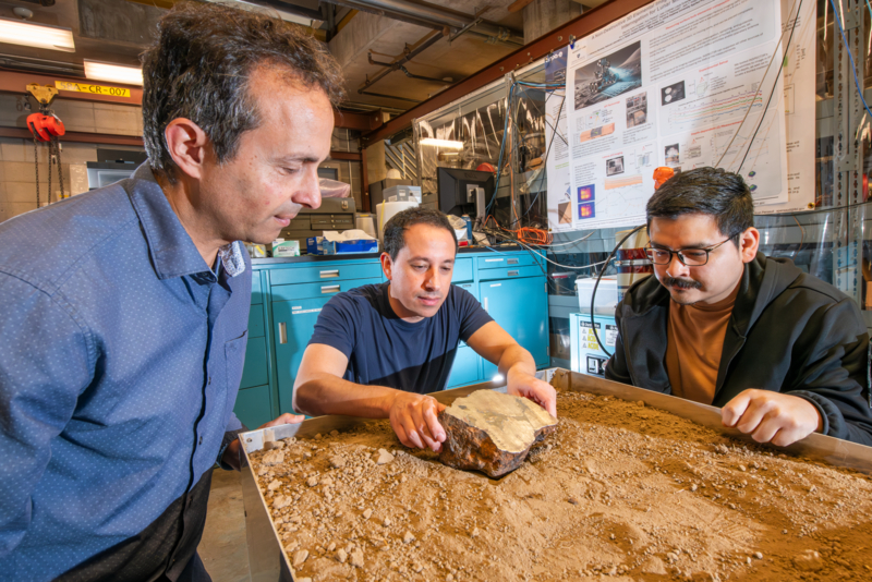
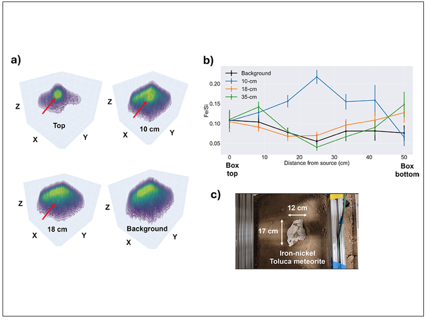
“Even when buried under thick layers of soil,” notes Ayllon Unzueta, “the instrument was able to pinpoint the meteorite’s location with centimeter-level accuracy.”
These test results, he says, demonstrate the instrument’s high sensitivity and spatial accuracy for subsurface imaging, confirming its ability to detect geochemically distinct objects in complex, layered soils such as those on the Moon, Mars, and asteroids. Additionally, it could help farmers optimize their land management practices or probe meteorites to reveal clues about their formation without destroying these rare and scientifically valuable objects.
However, before INSPECT3R can help uncover more of the geochemical secrets of other planets and asteroids, “there is still much work to do,” says Ayllon Unzueta.
While successfully tested in the lab, he says the system “is too heavy and consumes too much power for deploying on a planetary mission.”
The team aims to reduce its weight to approximately 10-12 kilograms and lower power consumption to less than 50 watts. While reaching these targets “poses significant engineering challenges,” says Ayllon Unzueta, “we believe they are achievable.”
“We are excited about the potential of INSPECT3R and are keenly focused on collaborating with NASA to refine this technology for mission readiness,” says Persaud. “Overcoming the engineering challenges of miniaturization and power efficiency will be essential for unlocking its full capabilities in future planetary missions.”
The research presented here was funded by NASA. The researchers would like to thank Arizona State University for the use of the Toluca iron-nickel meteorite and colleagues at Berkeley Lab for providing the terrestrial soil sample and their technical support.
To learn more…
Mauricio Ayllon Unzueta, Luoth Chou, Juan Cristhian Luque Gutierrez, Julius Meyer, Sanetra B. Newman, Patrick N. Peplowski, Arun Persaud, Jack T. Wilson, and Ann M. Parsons. “An in-situ 3D elemental imager for planetary missions based on active neutron interrogation,” npj Space Explor. 1, 12 (2025). https://doi.org/10.1038/s44453-025-00012-x
For more information on ATAP News articles, contact caw@lbl.gov.